Milan, 24 November 2018
I have a weakness for Japanese woodblock prints, that art form which we in the West tend to associate with Katsushika Hokusai. I mean, who hasn’t seen somewhere, in some form, his Great Wave off Kanagawa?

or his Fine Wind, Clear Morning?
![]() Or even his Kajikazawa in Kai Province
Or even his Kajikazawa in Kai Province

So when my wife and I were preparing for the week-long walk we undertook along the Nakasendo Way in Japan a few weeks ago it was with pleasure that I read that another artist well known for his woodblock prints, Utagawa Hiroshige, had, together with yet another artist, Keisai Eisen, made a series of prints specifically about this highway, The Sixty-nine Stations of the Kisokaido.
I should perhaps step back and explain to readers what the Nakasendo Way is. In Japan, as everywhere else where there has been a history of centralized government, rulers were anxious to build and maintain highways between important points in the country to ensure better control. The Japanese shogunate maintained a network of five such highways, all radiating out of the capital Edo (now Tokyo), with a series of officially-approved post towns along each route where the weary traveler could rest for the night, and change horses and obtain porters for the next stage of the journey.
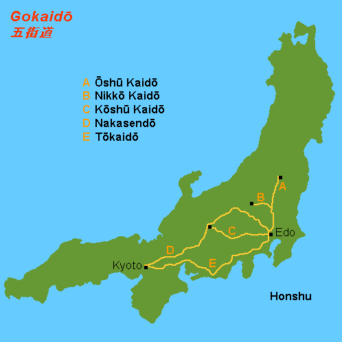
Two of these highways led to Kyoto. One we could call the low road, because it ran along the coast (E in the map), and the other we could call the high road since it threaded its way through the Japanese Alps, a block of mountains standing between Edo/Tokyo and Kyoto (C and D in the map). The latter is the Nakasendo Way.
This print by Hiroshige, which shows a view across rice paddies of the post town of Nakatsugawa, gives a sense of what the road must have looked like in the shogunate period.

The prints were prepared in the late 1830s, early 1840s, in the dying days of the shogunate. Some ten years later, in 1853, Commodore Matthew Perry entered Tokyo Bay with his black ships and forced the country to open up.

This was the start of the cataclysmic changes which led to modern Japan. Much of the Nakasendo Way was wiped out in the country’s ensuing rush to modernity. This map, which overlays the trace of the Nakasendo Way on a modern map of Japan, shows the problem.

Many of the modern roads followed the course of the old road and thereby obliterated long stretches of it when they were built, while Japan’s skyrocketing population meant that every post town expanded way beyond its original limits, further obliterating the old road, and the calls for modern housing meant many of the old inns, shops, and houses in the post towns were razed to the ground to make way for brick and concrete.
If I write all this, it is because I had hoped to be able to match up at least some of views along our walk with Hiroshige’s and Eisen’s prints. We read that the portion of the Nakasendo Way which we were going to walk along, from Oi to Karuizawa, was the most unspoiled. So when, on the first day of our walk, my wife and I visited a museum dedicated to Hiroshige, I took photos of all the prints covering our section of the walk, in the pleasurable anticipation that at least at a few points along the way I would be able to stop and say “Ooh look, see how it’s changed since Hiroshige’s/Eisen’s time!”
Alas, it was not to be. We didn’t see a single view which I could relate in any way to any of the two men’s prints. Partly it was because so much has changed in the built environment along the route. Partly it was because the organizers of the walk actually made us do large chunks off the Nakasendo Way proper so that we wouldn’t be walking along modern roads and highways. But partly it was because, as I came to realize, the two artists were not interested in giving the viewer faithful renderings of places along the road; rather, they wanted to record the sensations of being a traveler on the road.
With that in mind, let me give the readers a sense of what my wife and I saw as we hiked along highway and byway from Oi to Karuizawa. We started in Oi on a beautiful day, not at all like the day Hiroshige chose for his print of Oi, where we see luckless travelers tramping along through deep snow.

Our guidance notes informed us that nowadays the trace of the Nakasendo Way is marked by the road sporting a special top of asphalt mixed with little yellow stones.

Following this trace (which in truth we really only had for the first day or two) made me feel a bit like Dorothy and her friends on the Yellow Brick Road.

Following our speckled roadway, we passed through the old post towns of Nakatsugawa and Ochiai. These were once two distinct post towns but now have expanded outwards and bled into each other, so it is difficult to know where one ends and the other begins. I have already inserted Hiroshige’s print of Nakasendo. Here is his print for Ochiai.

The two can be compared to this photo of the modern town of Nakatsugawa.
 It’s a little hard not to feel a sense of loss.
At the exit of Ochiai, we crossed a bridge from which we had this perspective of a waterfall.

Charming – but not as dramatic as this print by Eisen of the river at Nojiri
 Something has been lost in the taming of nature.
Thereafter, we climbed steadily up towards Magome Pass, along an old piece of flagged roadway through a pine forest

before stopping for the night at an inn.

As in all the inns we stayed at, we were invited to wash off the aches and pains of the journey in the common hot tub and change into yukatas for dinner – something travelers had been doing along the Nakasendo Way for centuries, as this print by Hiroshige attests (note the man at the back soaking in the tub).
![]()
From the window of our room – strictly tatami, and no en-suite bathroom – we had a view of the inn’s garden.

I was reminded of a haiku by the master poet Matsuo Bashō
furu ike ya
kawazu tobikomu
mizu no oto
an ancient pond
a frog jumps in
the splash of water
Bashō traveled the old highways of Japan in the late 1600s and composed haiku along the way. Two seem particularly apposite for this autumn walk of ours:
No one travels along
this way but I
this autumn evening
Autumn evening: on a withered bough
A solitary crow is sitting now.
The next morning, the weather had turned bad and we left the inn under the rain.

With all our modern gear, we had it much better than some of the poor travelers depicted by Hiroshige tramping along under the rain

or running for shelter in a downpour.

We passed a Shinto shrine buried deep in the trees, whose entrance was guarded by a torii gate.

The same timeIess torii gate worked its way into one of Hiroshige’s prints.

The happy peasants are not so timeless, it seems. We saw no-one, throughout our entire walk, working in the fields.
We arrived in the old post town of Magome which, our guidance notes observed, is one of the better preserved post towns. And we arrived early enough to avoid the hordes of tourists which normally flood the place.


Magome is the birthplace of the novelist Shimazaki Toson. One of his most famous novels, Before the Dawn, is set in Magome at the time of the wrenching change from the Tokugawa shogunate to Meiji Restoration. As one review puts it, “Shimazaki shows that the Tokugawa shogunate, for all its repressiveness, had much to commend it; that the restoration, for all its successes, created a great deal of frustration and disillusion.” I must confess to having never read the book, but now that I’ve walked the Walk and seen all the changes that Japan’s opening up has wrought I think it’s time for me to do so.
We now began the walk up to Magome Pass. The higher altitudes were finally bringing the autumns colours to us.


The Magome Pass is nothing today but a tricky point where the walker has to be careful in crossing the road so as not to end up as roadkill. But Eisen and Hiroshige each presented the pass as backbreaking work for those carrying heavy loads along the route.


As we walked down the other side, carrying just a small rucksack

I could not but reflect that our lives had been made much easier by the modern road: while we walked, the bulk of our luggage was being transferred from inn to inn by car.
We soon came across an old tea house, which has been serving weary travelers tea on their way up to, or down from, the Pass since time immemorial.

Hiroshige preserved one such stopping-off place in one of his prints.

Local volunteers keep the tea house going, offering tea (and, our guidance notes informed us, sometimes songs) to the walker who is willing to tarry a while, which we willingly did.

After a cup of tea, we were on our way again, reaching our inn on the outskirts of the old post town of Tsumago. As we saw later that afternoon, Tsumago was another post town which has elected to preserve itself for the tourist trade.


The only thing that struck me about the place was the strange habit which the locals had of hanging persimmons, ripe now all over Japan, outside their houses to dry. If nothing else, it made for a pretty photo.

After Tsumago, our walking deviated from the Nakasendo Way. The next day, on our walk from Tsumago to Kiso-Fukushima, we took an alternative route through the mountains, which in the old days was used when rock slides and other hazards blocked the normal route. Gone was the speckled roadway. It was rougher, wilder, and altogether more beautiful.


This brought us to Nojiri, from where, with a bow to modernity, we took a train to Kiso-Fukushima. Our entry to the town was this.
![]()
This is how the town’s entry looked like in Hiroshige’s time.
![]()
After an evening session in the inn’s Onsen (that Japanese institution of public bathing in mineral waters channeled from hot springs) and a good sleep, we started our next day with a visit to Kiso-Fukushima’s Zen rock garden, reputed to be the biggest in Japan. As an aficionado of rock gardens, I couldn’t miss it.

Well, as they say “bigger is not necessarily better”. I’m not sure I approve of that use of white lines in the design.
Here again, we strayed off the Nakasendo Way, taking the old Hida Way, a salt and medicinal herb trade route. We started at the Karasawa no taki falls.

We climbed up through some beautiful forest

to the Jizo Pass. It was marked by a little statue which someone had thoughtfully covered with a hat and a bib to keep it warm during the winter.

Just before heading down the other side, I gave a thought to those other travelers which Eisen had depicted also taking a break at the top of a pass.

After a lunch in beautiful sunshine gazing out at Mount Ontake in the distance (a volcano, I have since learned, which blew its top not too long ago)

we headed out for our afternoon walk over Nishino-toge pass, about which I have no memory and no photos – I must have been tired.
And so to our final day of walking, which saw us coming back to Kiso-Fukushima by bus, take a train to Yabuhara, and from there walk to the old post town of Narai. The walk took us to the top of Torii-toge Pass

and from there down to Narai. Narai is one long street of well preserved houses.


I could see no relation whatever with Eisen’s print of Narai

although what I saw rather reminded me of his print of another post town, Sakamoto.

A final reminder, if ever I needed one, that my initial dream of matching woodblock prints by either men to what I was seeing on the ground was an exercise doomed to failure.
After a late lunch, we hurried to the station to catch a series of trains to our final destination, the old post town of Karuizawa. As in Hiroshige’s print of Karuizawa

we arrived in darkness, although we enjoyed a slap-up meal at our inn rather than smoking what looks to me suspiciously like opium pipes. Perhaps the poor buggers didn’t have the cash for a good nosh.
The next day, we took that super-modern form of transportation, the bullet train, and headed to Osaka to catch our plane back home. My wife and I have already agreed that next year, if we go back to Japan, we will do another walk. The question is where.
________________________________
Photos: all ours, except:
Hokusai, Great Wave off Kanagawa: https://en.wikipedia.org/wiki/The_Great_Wave_off_Kanagawa
Hokusai, Fine Wind Clear Morning: https://en.wikipedia.org/wiki/Fine_Wind,_Clear_Morning
Hokusai, Kajikazawa in Kai Province: https://www.metmuseum.org/art/collection/search/39656
Edo five routes: https://en.wikipedia.org/wiki/Edo_Five_Routes
Perry’s ship enters Tokyo Bay: https://medium.com/tomorrow-in-progress/when-black-ships-bring-the-future-9c7456050fcc
Nakasendo route on modern map: https://sites.google.com/site/kisokaido/presentation-nakasendo-kisokaido
Yellow Brick Road: http://fortune.com/2018/11/08/wizard-of-oz-script-auction/
Modern Nakatsugawa: https://photorator.com/photo/57577/spring-day-nakatsugawa-japan-
Kiso-Fuskushima station: https://en.wikipedia.org/wiki/Kiso-Fukushima_Station
Karasawa no Taki falls: https://www.getaway.co.za/travel-ideas/walking-through-japan/

2 thoughts on “THE NAKASENDO WAY”