Milan, 29 November 2019
My wife and I recently accompanied our son on a short business trip he was making to a small place to the north of Milan, near Lake Maggiore. He was going there to look over a company. We went along to share the driving and visit the local area. The company he was visiting happened to be very close to the point where a few weeks previously we had given up a walk in the area (the one where we had stumbled across several very lovely varieties of mushrooms), so we decided that we would use the occasion to visit what would have been the end point of our walk had we finished it.
That end point was the village of Orta San Giulio, which sits on a peninsula jutting out into Lake Orta. This is a small lake, the most westward of that series of lakes which form a necklace at the base of the Alps, between Verona to the east and Novara to the west. Readers with good eyes will see Lake Orta, marked with a red pin, to the far left on the map below.

Once we had deposited our son at the gates of the company he was visiting, we set off to Orta San Giulio. It was not, truth be told, the best day to visit anything: it was grey and drizzly, the kind of day that in my mind will be forever linked to the UK. But that didn’t stop us appreciating the scene that unfolded before our eyes as we arrived at the lake’s southernmost tip and took the road which hugged its eastern coast. My wife and I took no photos during our little tour, and the lake under the rain seems to have no fans among the legions of persons who post photos on the internet, so I can only describe to readers what we saw.
As we wound our way along the coast, with the wipers sweeping regularly across the windscreen, the trees covering the slopes which fell steeply into the lake’s waters – trees vested in their brown and reds of late autumn – began to give way to large estates with equally steep but more manicured grounds, the kinds of estates which I associate with the late 19th Century. Out on the water, dimly at first but ever more visible as we got closer to the village of Orta San Giulio, we discerned through the drizzle an island, the Isola San Giulio. The road began to climb to the top of the ridge of the peninsula along whose outer edge Orta San Giulio is built. Once we reached the top, we turned off the main road and made our way down to the village itself, passing as we did other, smaller estates climbing the side of the hill. When the road reached the water’s edge, it turned cobbled and narrowed into a single lane. We found a place to park and continued on foot, huddling under our umbrellas. Apart from a cat or two, we had the place to ourselves. Soon we were walking between rows of old houses on both sides of the street and only got an occasional glimpse of the lake down a side alley. But all at once, we entered the village’s main square, Piazza Motta, and there had a full view, across the square’s wet and windswept flagstones, of the lake and Isola San Giulio hovering on its waters in the middle distance. We could now make out the buildings on the island, in particular a Romanesque campanile on the water’s edge and a big hulking building, looking in all respects like an army barracks, which dominated the island’s centre point. We admired the view, looked curiously at an old hotel, now very much worse for wear, which occupied one whole side of the square, noted the street at the back of the square which, the signposts informed us, took one up to the Sacro Monte d’Orta, the Sacred Mountain of Orta, and then headed back to the car. It was time to go and pick up our son, and anyway it really was too wet and cold to explore any further. “For another time!” we promised each other. Maybe this Spring; there is a train we can take from Novara to Orta San Giulio.
In the meantime, though, I feel I must give my readers some idea of what we saw, or perhaps more accurately what we might be seeing when we come back in better weather. As is my habit, I’ve also been mugging up on the lake’s history and so can use this occasion to tell my wife – faithful reader of my posts – and any other interested readers about what I’ve learned.
So here is a photo album which I’ve cobbled together with other people’s pictures posted on the internet.
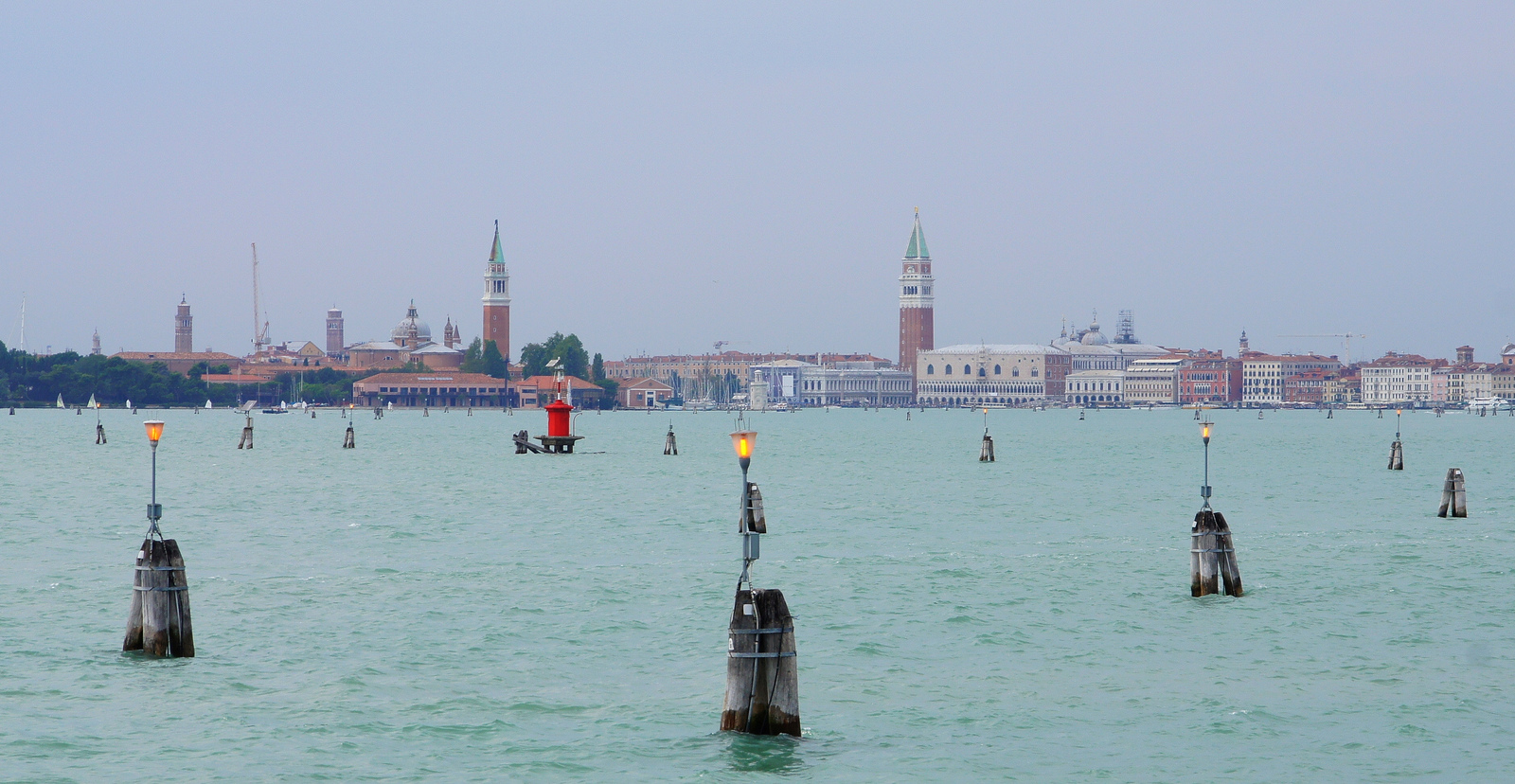
This is what the lake looks like on a good day from its south end, the end that we first saw it from.

Isola San Giulio is visible, along with a few houses of Orta San Giulio to the right. The pre-Alps rise up in the background.
As we turned off the main road down to Orta San Giulio, we passed this frothy building.

It is Villa Crespi. It was commissioned in 1879 by a wealthy cotton merchant by the name of Cristoforo Crespi and built in the Moorish Revival style. I suppose it is a somewhat outlandish example of what was happening around all of northern Italy’s lakes during that period: rich (or enriched) industrialists and bourgeois joined the aristocracy in building summer homes on the lakes. The same phenomenon certainly happened on Lakes Como and Maggiore (we see those villas every time we walk around those two lakes) and no doubt on Lake Garda (which still awaits a visit from us). Quite frankly, this particular building reminds me of some of the cinemas which dotted British cities when I was young, but at least this one continues to serve a decent purpose: it is a luxury hotel and home to the restaurant of one Antonino Cannavacciuolo (a well-known chef on Italian TV, I have read).
Certainly Lake Orta must have been a popular playground for the wealthier classes of the late 19th Century. It hosted the first ever European Rowing Championship in 1893 (rowing in Italy being considered a very aristocratic sport) and various national rowing championships thereafter, as this poster of 1909 attests (for an event, readers will note, “under the patronage of HM the King” [of Italy, of course]).

What happened in the following decades is a classic example of how not to manage a lake – but we will get to that later.
This was the narrow street we walked down after parking the car: Via Giovanetti.

It was pleasant to walk along under the rain; it looks even more pleasant on a sunny day.
And this is the village’s main square, Piazza Motta.

I’m not an expert on real estate but it does seem strange to me that the old hotel we see across the square in the photo (called, rather prosaically, Hotel Orta) has not been snapped up by someone and refurbished. There cannot be many places which have this nice a view when one steps out of the lobby onto the street:

Down by the lakeside at the foot of the square one catches the boat to go over to the Isola San Giulio, which, as we get closer, will look like this,

while we leave Orta San Giulio literally in our wake.

I think a little bit of history is in order here, because Isola San Giuglio has always been at the centre of the lake’s story.
The island gets its name from St. Julius, a possibly legendary saint who is said to have christianized the area around the end of the 4th Century AD. It is narrated that Julius and his brother Julian were two Greeks who somehow made it to Italy and were instructed by Emperor Theodosius I to destroy pagan altars and sacred woods and to build Christian churches. Which they did with a vengeance. The little church which Julius built on the island is said to have been the hundredth – and last – church he built. There are the usual colourful stories of his doings like, for instance, this one: having decided that he would build his last church on the island but finding no-one willing to take him there he laid his mantle on the water and miraculously sailed over to the island. As a final aside on this saint, he made it to sainthood, but – rather unfairly, I think, since the two worked hand-in-hand in their proselytizing mission – his brother Julian did not.
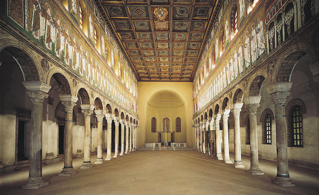
In any event, the first little church was succeeded by a larger one built in the 6th Century, which itself was succeeded by an even larger one built in the 12th Century; it was later nominated a basilica. That is the building we see today (although it has been much remodelled inside, as we will see, and squeezed in between houses built in later centuries). It is its campanile which we noticed when we were standing in Piazza Motta that cold and rainy day gazing out towards the island.

The island’s religious vocation was always in conflict with its obvious military importance. As this map shows, Lake Orta was one of two natural passageways for anyone crossing the Alps at the Simplon Pass to get down into the Po River plain and all its riches – the other was along the shores of Lake Maggiore. The red pin shows the location of the Simplon Pass in the map.

Having crossed the Simplon, armies would march down (or peaceful merchant trains would lumber down) the valley of the River Ossola and then either go along Lake Maggiore or march up to Lake Orta and then pass through the valley at the other end. A Frankish army did that in 590 AD, marching into territory that was claimed by the Longobards. A Longobard Duke, Mimulfo by name, who was entrenched in the island, seems to have just let the Franks through. For this betrayal, the Longobard King Childebert had Mimulfo beheaded on the island. (A French Corps also crossed the Simplon in 1800, as part of Napoleon’s campaign in Italy; I have no idea which of the two routes they used to get to Milan)
The island was also a useful place to hole up if hostile armies were around. To this end, a castle was built there as early as the 900s AD, reconverting some of the church buildings to military use and generally constricting how the church and its buildings could be expanded. By then, the Longobards had been defeated by the Carolingian Franks and northern Italy had become part of the Holy Roman Empire. The Emperors were traditionally also Kings of Italy, and northern Italy was therefore impacted by Imperial policies and politics. Around the turn of the first millennium, a struggle started in northern Italy between the smaller noble houses, many of Longobard origin, and the larger noble houses and the bishops, who owed their positions and land to the Emperors. The smaller nobles wanted – not unsurprisingly – to have their own, local king, while the bigger nobles and bishops wanted to continue to be beholden to an Emperor far away on the other side of the Alps who left them to pretty much run the show as they wanted. In 945, at a time of Imperial weakness, the smaller nobles got the upper hand and elected one their own, Lothair, as King of Italy. He was quickly replaced by Berengar, whose family was powerful in the region around Lake Orta. By this time, the Empire was back on an even keel and, at the request of the Northern Italian bishops, the new Emperor Otto I sent his son Liudolf with a large army over the Alps to deal with this upstart. Berengar’s family split up and holed up in various castles which the family controlled. Berengar, together with one of his sons, chose the castle on Isola San Giuglio. There, he was besieged by Liudolf and eventually surrendered. For some reason, Liudolf let both Berengar and his son go free. They went off and holed up in another castle of theirs in Romagna. Several months later, Liudolf died, officially of a fever although it was whispered that Berengar’s people had got to him and poisoned him. With Liudolf’s death his army melted away, and Berengar came out of his castle in Romagna to proclaim himself King of Italy once more. More Italian bishops headed north over the Alps, besieging Otto to come personally to deal with Berengar. This he did in 961, but first he went to Rome to have the Pope proclaim him Emperor and then to Pavia to have himself proclaimed King of Italy. By 962 he was ready to deal with Berengar, who adopted the same strategy: split up the family and hole up in various castles, except that this time it was his wife Willa who got to be in the castle on Isola san Giuglio (together with the family treasure) while Berengar headed for the castle in Romagna. Otto decided to go after Willa and history repeated itself: a siege of several months of the castle on Isola San Giulio followed by its capitulation. Again, Willa was allowed to go free (but not the family treasure) and she joined her husband. This time, though, Otto made sure that the castle stayed under Imperial control. As for Berengar, he died four years later and none of his sons seem to have made any attempts to retake the throne. There was another revolt by the small nobles some 40 years later, when Berengar’s grand-nephew, Arduin, was proclaimed King of Italy, and Northern Italy was put through the same circus: The Emperor (this time Henry II) came over the Alps with a large army and put Arduin in his place; he went back to Germany with his army and Arduin came out of whatever castle he was hiding in and proclaimed himself King again; Henry II came back over the Alps with another large army and dealt with Arduin again, this time for good (without, though, putting him to death; I think the Longobard king Childebert had the right approach: off with their heads!) Italy was not to have an independent King again until Italian unification nearly 900 years later.
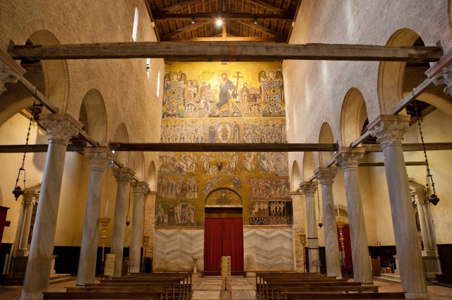
After that, Isola San Giulio seems to have been pivoted away from its martial use back to its religious vocation and the whole area became a bit of a rural backwater. Over the next two hundred years, the successive bishops of Novara maneuvered to gradually have the Emperor give over to them the southern part of the lake as a feudal principality, which they then ruled with what seems to have been distant benevolence for some five hundred years; the local notables were generally allowed to rule themselves as long as they paid the necessary tithes and taxes to the prince-bishop. I don’t know if the prince-bishops used any of these funds to make life better for the peoples of their little principality. They certainly did use some of their funds, as did pious pilgrims, to make the basilica ever more beautiful. From the 14th to the 18th centuries, the church’s look was “modernized”, with the latest Baroque additions giving the inside of the basilica its current look, and frescoes were added on every available surface, with the later ones sometimes obliterating the earlier ones. We have here the “modern” frescoes in the vault and dome (the picture also shows the baroque “scarification”).

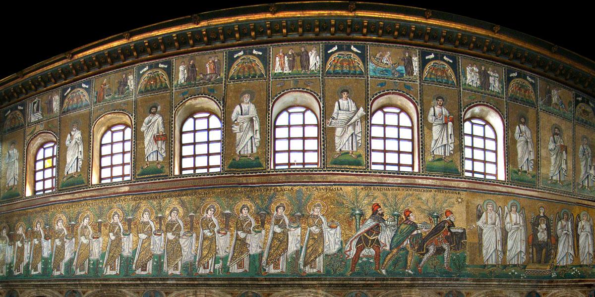
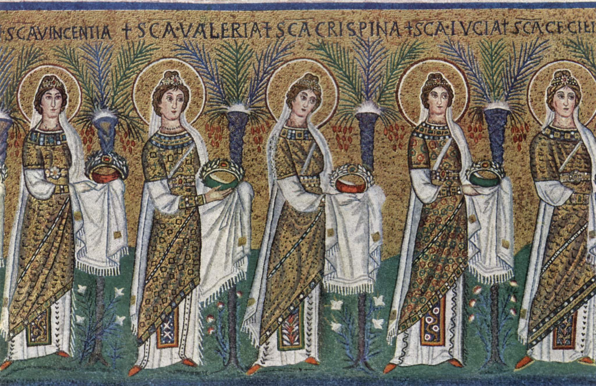
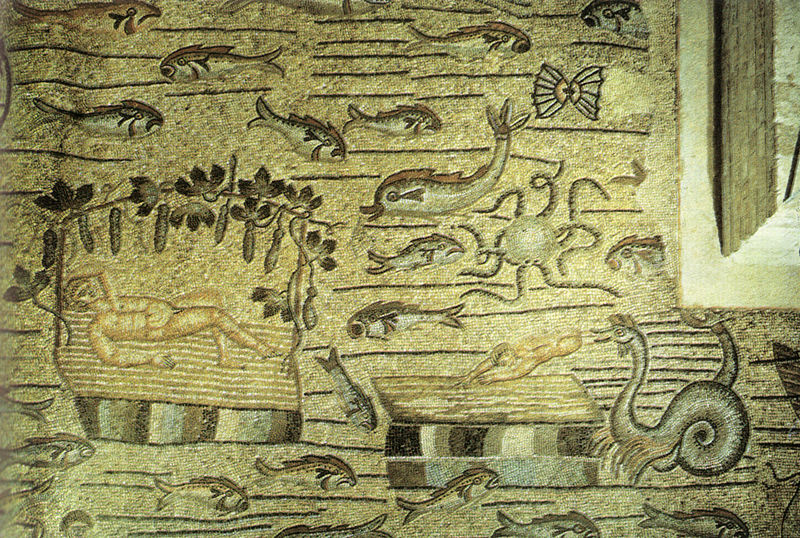
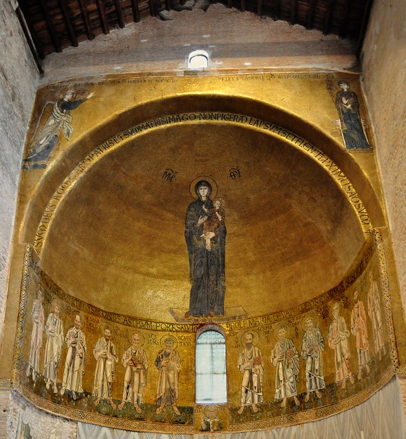
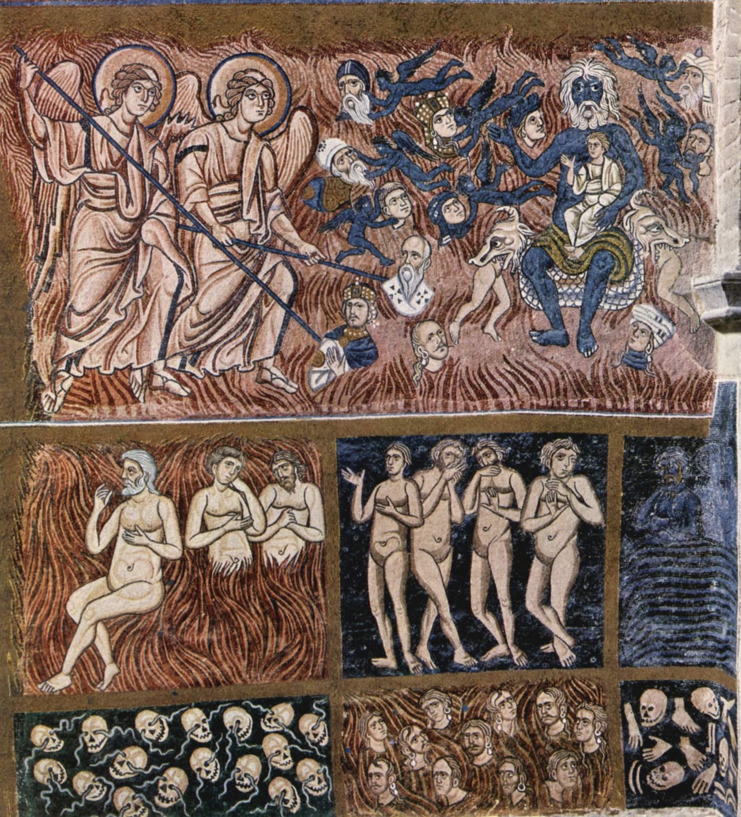
while here we have one of the earlier frescoes, which are now tucked away out of sight in the lateral aisles.

I have already made my feelings abundantly clear about baroque and later religious art in earlier posts, so I need hardly say that I prefer the earlier frescoes.
While all this religiosity was going on, life was not completely trouble-free in Isola San Giorgio and the surrounding principality. The end of the 15th, beginning of the 16th Centuries were agitated times in Italy and while this quiet corner of northern Italy was largely able to avoid the troubles, for a decade or so, 1520-30, the troubles came to it. In 1523, the plague broke out, in all likelihood brought to the area by refugees from Novara which had been sacked and pillaged by French troops fighting the Spaniards. But worse were the predations by the neighbouring lordlets, many of them from the Visconti family, who were attracted by the relative prosperity of the principality. Although officially the Duke of Milan was exhorting the lordlets to be good boys – these were church lands, after all – he probably unofficially supported them in their rapine, because he had his own quarrel with the Bishop of Novara over the ownership of this little principality: Novara and its province had come under Milanese dominion some two hundred years earlier. On some excuse, Orta San Giulio was sacked in 1524 by one Visconti lordlet and prisoners taken for ransom. In 1526 and ’27, the principality was forced by another Visconti lordlet to put up, for free, a company of Imperial soldiers. In 1528, the same Visconti lordlet decided to become Governor of the principality and moved into the castle on Isola San Giulio. When the locals besieged him there, a third Visconti lordlet came to his rescue and sacked Orta San Giulio a second time. In early 1529, a random Imperial army invaded the principality and demanded a huge payment to leave. The locals refused to pay and escaped to the island and the relative safety of its castle. After trying to take the castle a few times, the army gave up and left, sacking and pillaging as it went. A few months later, the third Visconti lordlet decided it was time to pillage some more and marched into the principality at the head of a band of soldiers. This time, the locals were “mad as hell and weren’t going to take it anymore”, as the saying goes; they were determined to resist. Grabbing what arms they had, they met the invaders and brought them to battle. The invaders made the classic mistake of thinking that these were just a bunch of peasants who would run away when the going got tough. But they didn’t; they fought like madmen. They were helped, it has to be said, by the marshy ground they had chosen, which meant that the invaders’ horsemen were neutralized. The result was that the Visconti lordlet and a good portion of his men were massacred. The other lordlets of the area took heed and desisted in their predations (probably aided by the fact that a general peace was finally brokered between the Great Powers fighting over Italy).
Thereafter, Isola San Giorgio and the rest of the principality slipped back into its state of feudal somnolence for another two hundred years. In 1735, Novara and its province were handed over by the Austrians to the House of Savoy. The-then Duke of Savoy (and King of Sardinia) Charles-Emmanuel III had no patience with quaint feudal relics in his lands like the Bishop of Novara’s principality around Lake Orta. Pressure was brought to bear and slowly, slowly the bishops divested themselves of their feudal rights to the principality in favour of the House of Savoy. By 1819, the deed was done: the principality was no more. It was just one more district in the lands of Piedmont and, after 1861, in the newly-unified kingdom of Italy.
As a sign of the changes, the remains of the castle on the island were dismantled completely in 1841 and in their place a huge seminary was built – it is that big blockhouse of a building which I thought were old army barracks. We have here an old postcard celebrating the seminarists.

The seminary is no more; it lasted a little less than a hundred years. But the religious vocation of the island continues. The basilica and seminary have been handed over to a congregation of Benedictine nuns – we have one here going through the rite of becoming a Bride of Christ.

The nuns have an interesting vocation. They study and translate ancient texts, and restore ancient fabrics and tapestries.
It is time to go back to Orta San Giulio and take that street at the back of Piazza Motta which we had noticed that cold and drizzly day, and which carries one up past this church to the Sacred Mountain of Orta.

The Sacred Mountain of Orta is one of a number of Sacred Mountains which were created in the late 16th, early 17th Centuries in Northern Italy. They were very much promoted by San Carlo Borromeo, Cardinal of Milan (whose very large nose I have mentioned in an earlier post). The original idea was to create places of pilgrimage which could stand in for the Medieval pilgrimages to the Holy Land, which was becoming harder and harder for pilgrims to reach. For San Carlo Borromeo, the Sacred Mountains were also to be a way to teach the little people, who had not had the benefit of an education, in an easily understandable way such mysteries as the Trinity but also the lives of Christ, the Virgin Mary, and great saints. To this end, the Sacred Mountains were made up of a series of chapels containing life-sized models in terracotta, backed up by frescoes on the chapel walls, each telling a story in a holy person’s life or making a point about some tricky theological concept: little theatrical pieces, if you will. I have mentioned the use of art to teach illiterate people about religion in an earlier post. With the growth of Protestantism, the Sacred Mountains took on a third purpose, that of combating these horrible heresies. That no doubt explains why there are so many Sacred Mountains in Northern Italy, where they were created as bulwarks against the tide of Protestantism that could be washing over the Alps at any minute. In fact, the Sacred Mountain of Orta is part of nine such Sacred Mountains in northern Italy which are now inscribed in UNESCO’s list of World Heritage Sites. In September, my wife and I visited another of these nine sites, at Varallo in Piedmont (where, coincidentally, we were once again accompanying our son on one of his business trips). I mentioned another of these sites, at Varese, in an earlier post I wrote about the fondness of religions around the world for sacrilizing mountains.
The Sacred Mountain of Orta is dedicated to the life of St. Francis, which pleases me no end since he must be my favourite saint, as I have mentioned in an earlier post. There are 20 chapels, laid out in a wooded landscape.

I don’t propose to show readers photos of them all. Just two can give readers a sense of what would await them were they to visit this Sacred Mountain (or any of the other Sacred Mountains for that matter).


I hope these scenes are in better shape than the ones we saw at Varallo, which were really rather tatty. Luckily, they were in the midst of being restored when we visited.
You get beautiful views over the lake from the Sacro Monte.

As you gaze down on this sunny scene, it’s hard to believe that a mere thirty years ago the lake was dead. Everything in it had been killed off by industries which were discharging their crap into the lake, turning it into the most acidic lake in the world. It started back in 1927, when the German company Bemberg, which was making rayon fibre using the cuprammonium process, set itself up on the lakeside. The plant’s copper and ammonium discharges quickly acidified the lake, killing all life in it in about two years. Bemberg made limp efforts to control the discharges, which did begin to finally show noticeable reductions in the late 1950s. But by then Bemberg had been joined by a host of small plants making metal consumer products; two of these companies, incidentally, went on to become global brands: Bialetti and Alessi.

Many of these plants included electroplating in their processes (that Alessi kettle is heavily chromed, for instance) and consequently toxic heavy metals such as chromium, zinc, copper and nickel were added to the filthy mix being discharged into the lake. As if that weren’t enough, the acidic waters of the lake released aluminium from the natural and normally harmless imissions of aluminosilicate into the lake, adding yet another toxic metal to the stew. Things only got better when the legislators eventually banged their fist on the table and passed Italy’s first water protection law in 1976 (the Legge Merli; I know it well, I referred to it countless times when as an environmental consultant I would tell Italian companies they needed to control their water discharges). Suddenly, companies which had claimed for years that it was impossible to control their discharges and remain in business found – surprise, surprise – that actually it was possible to control them and stay in business. But it took more than just forcing companies to properly control their discharges to get the lake’s pH back to normal. A massive liming operation was required, where calcium carbonate was added to the lake. A boat was specially made for the purpose. Lime was first sprayed on the surface.

But that wasn’t enough. Lime had to be injected deep into the lake, below the thermocline. It took twenty years to restore what had taken a mere two to destroy. The lake is now more or less OK: “fishable, swimmable”, in the catchy phrase of the US’s first water protection law, although the planctonic populations are not quite right yet.
Well, on that somewhat hopeful note, I leave my readers. Maybe some of them will make it to Lake Orta one day. My wife and I certainly will, when Spring comes rolling round again.


